Words by Prof. Saviour Formosa
“Extreme weather leaves Mediterranean countries picking up the pieces. Egypt and Lebanon were the hardest hit with over 1.2 million people displaced overnight. Malta didn’t fare much better. The authorities have reported over 2,300 dead or missing, thousand injured and 74,000 persons displaced. Power cuts have been reported all over the island after Turbine Two tripped at the Delimara Power Station. Enemalta have not replied. The islands have taken a major blow to their infrastructure. Debris has been reported 1 km away from the coasts. The AFM and emergency responses were immediately dispatched and are starting to clear arterial roads. Insurance companies are still counting the costs. Valletta, Floriana and parts of Isla were protected from the storm surge by centuries-old Knight’s fortifications. The following localities have been affected: Birgu, Bormia, Kalkara, Marsa, Gzira, Msida, Pietà, San Giljan, Sliema, Ta’Xbiex, Xghajra, Birzebbuga, Marsascala, Marsaxlokk, Xlendi and Marsalforn. “
The above cutout could become reality if a Category 3 storm lashes Malta with 178 to 208 km per hour winds. The chances are minimal but too probable to ignore, since in 1995 a similar storm formed close to the Maltese Islands followed by others in 1996, 2006, and 2011. Below are two scenarios that compare Malta as it currently stands against an island with a solid disaster management plan.
[ SCENARIO 1 – AN UNPREPARED ISLAND]
The emergency forces have been inundated with calls for help and have few plans to operate a workable rescue effort. Key personnel were lost at home or while rushing to the scene, since the infrastructure has been knocked out, paralysing the island. Power surges or power cuts have caused fires all over the Islands creating an apocalyptic scenario. With the storm still raging, the lack of a back-end ICT network has rendered communication near impossible.
[ SCENARIO 2 – THE IDEAL SCENARIO]
A fleet of small aerial drones is monitoring the disaster. The authorities are using them to identify the hardest hit areas and map out corridors that allow access on the ground. Emergency vehicles are being deployed safely. Services will be redeployed after safety assessments and clearing of the main infrastructure. Paramedics, NGO rescue teams, and armed forces help move people to safer grounds and carry out rescue operations. Community buildings on higher ground are converted into temporary shelters. In turn, decision-makers are kept informed using an Emergency Room for effective relief.
Back to 2013, extreme weather events are gradually gaining ground around the world linked to a changing climate. Building scenarios of possible disasters is an essential way to prepare a nation. Malta currently lacks a comprehensive risk assessment and the infrastructure to cope with the storm I described above.
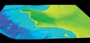
Since 2006, I have been co-ordinating a €4.4 million ERDF project to introduce a unique map of the Maltese Islands. This tool will provide a solid foundation to build relief efforts. It goes far beyond a digital map and integrates height data, underwater depths, building heights, geographical features, environmental protection legislation, development planning studies, and population studies. The project started off from a number of directives studying air, water, noise, radiation, and soil has matured into a full-blown tool that can be used for relief efforts, but also to protect the environment and aid societal change. The layers of information serve civil protection, architects, town planners, geographers and geologists, archeologists, social scientists and criminologists to name a few. This tool will allow 3D simulations based on new data to build new scenarios for any problem the Maltese Islands might face. We will be launching the free tool this June.
Riding the Wave
Having this tool up and running will allow an exciting new wave of analysis. It will empower University Faculties and Institutes to contribute to an integrated research base through the generation of digital terrain 3D models. They can be used for urban and transport planning, environmental impact assessments, development infringement analysis, security review, modeling of runoff water, and enforcement of land use activities. Experts can also study, monitor, analyse, and protect those areas that are vulnerable. Spin-offs from the results include updated nautical charts, landscape assessment, direct line of sight studies to determine unobstructed views of historical buildings, and viewshed analysis that allows landscapes to be seen from every angle. The results will also allow for cross-thematic studies in the physical, social, and environmental domains.
“We could also test the first underwater hotel within an entirely accurate enviroment”
Having been structured around a number of international directives, the project will ensure the free delivery of all data to the general public. This is the result of an integrated exercise to adhere to EU requirements.
All data from this project will be made viewable and disseminated through a web portal known as a Shared Environmental Information System (SEIS). Within the SEIS the whole of the Maltese Islands will be uploaded followed by more well-known platforms like, OSGrid, OpenSimand, ScienceSim, Second Life, and Google Earth. This prospect opens entire venues for online commerce, gaming, tourism, virtual development testing, and social interactions in a virtual reality that mimics or enhances reality. It could take Facebook and Minecraft to a whole new level in Malta.
Testing of environmental management plans, town planning, and a million other scenarios can be taken up across entire academic domains. Imagine testing a new paragliding suit over the Dingli Cliffs and including precise wind pattern fluctuations. We could also test the first underwater hotel within an entirely accurate environment, or an array of wave powered electricity generators that can be assaulted with all kinds of weather conditions. The islands could also be bridged with a new tunnel or single span bridge employing new materials and tested using this technology. The possibilities are endless.
In terms of project outputs, from here, the sky is the limit. Reruns of the bathymetric and terrestrial LIDAR (Light Detection and Ranging) scans would enable change analysis, which is when the laser light reflected by surfaces is used to measure changes in the physical structure of historical buildings or cliff sides. Future technology developments are needed for an aerial ground-penetrating radar scan of the Maltese Islands to explore and protect our underground heritage. By investing in more research and technologies, this map could be upgraded and made more powerful.
Revisiting the Scenarios
The simulation of extreme weather events is now within reach. The infrastructural data is now available, while we could glean information about the population from census and common database data. Other ERDF projects also have huge readily available datasets.
If Malta adopts scenario two, a storm would kick off a fleet of drones to scan buildings and infrastructure for damage. In turn, this information would raise the alarm for critical areas that need instant intervention. Other sensors will measure radioactivity or pollutant emissions, whilst others would measure heat signatures of trapped persons. Our rescue teams could be efficient, effective, and save the largest number of people. Flash flooding can be predicted based on the rate of precipitation and slope analysis, allowing the authorities to work on the most at-risk localities. By combining this strategy with immediate generation of risk maps and disaster simulations, the loss of life would be minimised and an alarm system set in place.
Malta needs to be prepared and its authorities must help develop response strategies. In the next few years, scenarios need to be tested, followed up by solid strategies to help brace the Island. Only then will Malta prevent that horrific newspaper cutout.
This €4.4 million project is being implemented by the Environment and Planning Agency, the University of Malta, the Malta Resources Authority, the National Statistics Office, and the Environmental Health. It is co-financed by the European Regional Development Fund. The project will be freely available to the public as outlined by the Commission’s Communication COM (2008) 46 Final “Towards a Shared Environmental Information System”, the INSPIRE Directive (Directive 2007/2/EC), and the Aarhus Convention.
https://www.youtube.com/watch?v=VwCNHvD2gqY
Find out more:
– Formosa S., V., Magri, J., Neuschmid, & M., Schrenk, (2011). Sharing integrated spatial and thematic data: the CRISOLA case for Malta and the European project Plan4all process, Future Internet 2011, 3(4), 344-361; doi:10.3390/fi3040344,
ISSN 1999-5903
– Formosa S., Sciberras, E., and Formosa Pace J., (2012). Taking the Leap: From Disparate Data to a Fully Interactive SEIS for the Maltese Islands in Murgante B., Gervasi O., Misra S., Nedjah N., Rocha A.M., Taniar D., and Apduhan B.O., (Eds.), Computational Science and its Applications – ICCSA 2012,
LNCS 7334, Springer, Heidelberg,
ISBN 978-3-642-31074-4
– Formosa S., (2013). Maltese Building Blocks for Geographical and Crime Sciences, Journal of Geography and Geology, Vol. 5, No. 1,
ISSN 1916-9779 (Print)
ISSN 1916-9787 (Online)
– Formosa S., and Sciberras, E., (2013). Mapping the Micro State: Connecting LIDAR, SEIS, Aarhus and INSPIRE, GEOconnexion International,
Vol 12(1), 32-33, ISSN1476-8941