Sensing the SIntegraM: two-decadal endeavour for spatial data harmonisation and governance
Chapter 3: Emergent Realities for Social Wellbeing: Environmental, Spatial and Social Pathways.
Abstract
Initialising a stepped approach towards access to spatial data never purports to offer a dull moment. Stepped approaches that aim to make sense of data and harmonisation are hindered by capital and recurrent issues that pertain to the creation and maintenance of systems and protocols whilst governance across a national landscape impinges stressors on any system. The SIntegraM concept was initiated in 1995 on a two pronged process, that pertaining to a simultaneous but independent bottom-up and top-down process that had striven to achieve success but were constrained by the early concept hiccups that did not empower the project due to failed uptake by diverse entities and a defunct base mapping system. SIntegraM saw the coming together of two project champions who spent four years to morph their conceptualisation, bring together all public entities, present a spatial data integrative approach and eventually apply for basal funds to implement change.
The result was based on an integrated approach to the data cycle, innovation concepts on data capture, integration and capture, the creation of a data-sharing protocol structure within a protected and secure environment and also the newly innovative action where hardware and apparatus will be shared by all government entities, under the gather-once / use-many philosophy. The stepped approach moved away from the vicious cycle of data hoarding and towards a spiral based on the need to use such resultant information eventually growing into a complex but readily available system that is driven by the Maltese SIntegraM’s unique conceptualisation and implementation foresight.
Introduction
The process of data mangement and its transposition to spatial formats was conceptualised in an idea that started off in 1995 and required a mentality shift to ensure readiness in data and information sharing, the abolition of data hoarding and the creation of collaborative protocols. This process ensures a gather-one/use-many scenario within a spatial construct.
The ERDF project was conceptualised and driven by the author who spanned the diverse entities with collaboration from the Planning Authority and the Faculty for Social Wellbeing at the University of Malta which project was awarded €7 million. This initiated a process whereby data is built around a spatial-core and which resultant information could be used by both policy makers and academics to create knowledge and in turn action. This entailed a process that took 22-years to achieve fruition, Such was required due to the need to ensure the elimination of barriers created through lack of access to data (Formosa, 2010), the transposition of the INSPIRE Directive (OJ, 2007) and a collaborative approach across all government entities. The process was aided through the successful conclusion of a prior €5 million ERDF project that enabled the creation and dissemination of environmental and 3D terrestrial and bathymetric data (MEPA, 2009).
The SIntegraM (Spatial Data Integration for the Maltese Islands Spatial Data Integration for the Maltese Islands: Developing Integrated National Spatial Information Capacity) project, is being part-financed by the European Regional and Development Fund (ERDF) and is led by the Planning Authority with full partnership from all Ministries and their relative entities.
Figure 1: SIntegram
The project benefits the country as well as the University of Malta due to its cross-thematic approach that spans all Faculties and Institutes both through access to data, access to data capture and analytical technologies as well as access to expertise. The project delivers a strategic approach to spatial data, integration of vital base datasets, new legislation as well as training, The main concept is built around the creation of data creation protocols, information exchange, access to data, and inherently data protection and privacy, In terms of infrastructure, the project provides systems, equipment, data capture devices using aerial, terrestrial and marine technologies, in addition to analytical and dissemination tools that will ensure inter-governmental data dissemination, and national preparedness.
This concept of data sharing has been taken to another level where the protocols for sharing will span diverse domains through its philosophy to introduce an intra-government hardware and technology sharing. Such a concept will further break the ice towards ultimate ownership by all and removal of barriers to access to data.
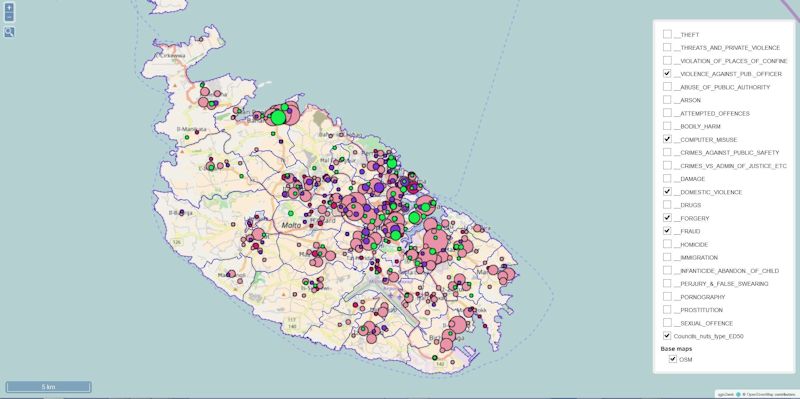
Examples of integrated research that span disciplines could include the analysis of air pollution as carried by air currents as affecting the health of children who live close to an amenity site or the investigation of potential development as it affects landscapes and skylines through a euclidean or viewshed approach, in turn resulting in the calculation of flooding that in turn alerts the Civil Protection and Transport entities to close off areas at risk. Population (Figure 1) and crimemaps also serve as a base service for safety and security (Figure 2). There are 22 years’ worth of ideas in the pipeline.
Figure 1: NSO population maps
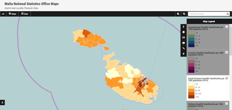
Source: (NSO Maps)
Figure 2: Crime maps
The project is set to change the way information is viewed, accessed and given academic value-added in turn enhancing the University's role in bringing about social change. As an example of an innovative data output, the project Cloudisle depicting 3D maps as emanating from the project will serve as a baseline for future 3D capture for analytical and operational management of national assets, predictive modelling and virtual tourism amongst other results. Figures 3a-b depict a topographic image (Figure 3a) of the Gozitan Ghajnielem cliff zone known as Xatt L-Ahmar which is depicted in Figure 3b as an elevation map showing the wreck of 3 sunken vessels named MV Xlendi (left), MV Karwela (centre) and MV Cominoland (left).
Figure 3: Cloudisle 3D
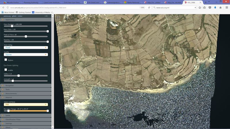
a) RGB map of Ghajnsielem cliff zone
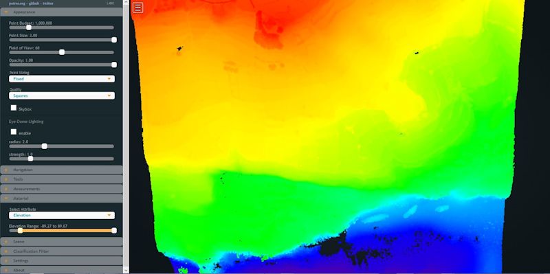
b) Elevation map of Ghajnsielem cliff zone depicting 3 wrecks
Source: (www.cloudisle.org)
Proposals for Change
SIntegraM’s drive towards geospatial DIKA (Data-Information-Knowledge-Action) was based on a conceptual to an implementational model, as defined from experiences that were garnered through various projects and case studies that helped build up a processed approach to spatial systems implementation. The following steps were undertaken as a procedural process (Cassar and Formosa, 2013):
Concept: As most mapping data processing requires updated or near real time information, which is governed by concepts and technologies that evolve rapidly, it is imperative that a solid foundation is laid to ensure Malta's readiness in all areas that deal with base and thematic mapping. Currently the state of affairs depends on dated basemaps, inter-agency charging systems, inconsistent approach to the data-cycle process, dispersed expertise, various software and isolated non-networked systems.
Malta needs to bring together these entities to ensure the setting up of a central organisation that serves all the country’s needs, the creation of base and thematic spatial information system, a regularly updated and enhanced information structure that serves all entities, and the integration of expertise.
This structure should ensure compliance with national and European/International legislation and commitments, simplification of procedures, free dissemination of information and inter-agency collaboration. Such a structure serves both for current requirements such as development monitoring, transport monitoring, infrastructural inventorisation, utilities' flows as well as deployment for foresight such as the real-time deployment of information in cases of emergencies. Only through an integrated information system can such be brought to a peak of excellence.
This proposal sought approval to develop a conceptual model and implementation process for the sourcing of EU ERDF funds aimed at creating the spatial entity, sourcing and integrating the players, creating information systems, acquiring in-situ and remote data harvesters, analysing the scenarios and implementing real-time and foresight contingency plans through scenario testing and disseminating the raw and processed information.
Technical: Spatial Data (or geographical information system) refers to those information streams that deal with location: data as it is related to a point in space. These are generally known as graphical information systems that allow one to view data in the form of a map or as online interactive systems. Systems in place include the PA mapserver, PA’s SEIS (Shared Environmental Information System), GoogleMaps and other similar systems. Since everything happens somewhere, the requirement for authoritative reference geospatial data is vital for all branches of central government. This necessitates the need for an increased awareness of the value of ‘place’ and ‘location’ as vital components in effective decision making and for linking public-sector information together. It is important to distinguish between levels of reference maps:- while free or web-based mapping are sufficient in locating the nearest restaurant, central government dealing with national and societal interests, and in some cases life-critical situations like disaster management, requires authoritative and quality-assured geospatial data at a national level.
Legacy: Malta is one of the forerunner countries that have attempted to gather, analyse and disseminate spatial (or geographical information) that cover the entire nation. The country’s size is an aiding factor, however, Malta has the same relative human and material resource capacity as other states.
International Requirements: Malta’s entry into the European Union has pushed the requirement to create these information structures towards locational analysis and reporting in over 70% of the Acquis. There has been an exponential growth in the use and proliferation of geospatial and location information in the past decade. More importantly this trend is expected to increase in the next five to ten years as technology-driven trends will impact geospatial data capture methods, making location information even more ubiquitous.
EU Legislation: Malta is party to the various legislations governing data (OJ, 1995; OJ 2003a, OJ, 2003b; OJ, 2003c; OJ, 2007) such as the Aarhus Convention, the INSPIRE Directive (EU Directive establishing an infrastructure for spatial information) and the SEIS initiative. All data reporting streams go through the EC (European Commission) and the EEA (European Environment Agency) and Malta has to report in spatial formats to these agencies.
Maltese Legislation: The production and maintenance of the national geographic database of Malta is defined as one of the functions and legal obligations of the Planning Authority laid out in Act No VII of 2016, Part V, Sub-article 38(e): “the carrying out of national mapping, including carrying out land surveys of specific areas and keeping up to date the national geographical database …”
Current Functionality: The PA’s mapping unit is tasked with carrying out the national mapping function. The unit’s core objective is to produce and maintain accurate, detailed, authoritative reference maps of the Maltese Islands, known as the large-scale topographic map (LSTM). This is composed of different layers that represent a collection of real-world features (such as buildings, roads, pavements), and abstract objects such as cartographic text. It includes a topography layer, an elevation layer, a Digital Terrain Model (DTM) layer, a geographic text layer, and the orthophoto map layer.
The national mapping function is a specialist function which benefits MEPA since the base map is intrinsically linked with several of the authority’s business processes, such as forward planning, plotting, development control, environment and enforcement. However the LSTM is also the de facto national spatial reference data, a strategic dataset that is indispensable to the wider national requirements comprising utilities, civil protection, transport, communication, emergency services, agriculture and health, to name a few. Government is thus a major stakeholder in the need for accurate, detailed and up-to-date authoritative geospatial data which act as the basic reference layer over which many other government entities can overlay their own specific geospatial themes and layers of interest. The LSTM is thus the basic reference layer that underpins the national Geographic Information System (GIS), otherwise known as a National Spatial Data Infrastructure (NSDI).
This NSDI is the vehicle through which geospatial information and public sector information can be shared in a standardised and cost effective manner by central and local government, public entities and indeed the general public. In turn a national GIS maximises the investment in information, ensuring that data are captured, maintained and managed once and shared by many. However a key element of an effective GIS is an authoritative and up-to-date reference database which brings together all the themes and layers of all the stakeholders in a standard, harmonised and interoperable platform.
The LSTM has a lengthy and specialist production process that requires the use of specialist suppliers, dedicated software and hardware, and specialist knowledge and skills. Topographic mapping represents the real world which is always changing. Therefore the challenge is to reflect the real world by constantly maintaining and updating the large-scale topographic map.
Issues at Stake: The technology and methods to produce and maintain digital geospatial data have undergone drastic changes in the last two decades since the Mapping Unit was initially set up in 1988. However, there has been no significant investment to upgrade the national mapping function in over a decade. The investment required to update and maintain the authoritative datasets and to upgrade the technology to exploit the new location-driven technology and trends is in the region of €1.5 - €2 million. This investment would entail a mixture of out-sourcing and in-house supply, data capture and quality control. While it is advantageous to outsource certain elements of the data-capture and production process of the base map, total divestment of the entire undertaking is not recommended since commercial interests may undermine the authoritative nature and trust of the reference datasets which are critical to the national interest and security.
Free Access: An emerging trend in other European states is that as part of their eGovernment strategy, free access to high quality reference authoritative data is being granted to the public. Reference authoritative data in such cases could include: geo-spatial businesses information, addresses, real properties, land tenure, and digital map data. This is viewed as a driver for efficiency and interoperability in the public sector, a stimulant for economic growth, and an opportunity for the creation of innovative digital services in the private sector. Free access has already been made available through the establishment of the Aarhus requirements and through the SEIS system depicted in Figure 4, which MEPA launched on the 18th October 2013 (www.seis.org.mt). The concept of ‘gather-once and use-many’ should enable all entities in Malta to create information and distribute it for free to all entities and the public due to its base funding mechanism that ensure tax-payer’s monies are returned in kind without the need to double charge for data that has already been paid for by the same citizens.
Figure 4: SEIS Portal
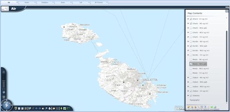
Source: (www.seismalta.org.mt)
Resultant Recommendation: The above exposition, supported by and expounded further in the attached paper, are the main reasons for the urgency to establish a national Spatial Information Structure and to approve in principal the establishment of a national GIS function and authorise PA to set such a system in place. The authorities were also requested to entrust the structure to investigate the best modus operandi for the setting up of a functional entity, explore the funding mechanisms for setup and implementation as well as ensure the delivery of the data to all interested parties and the public.
ERDF Funding: In addition, approval was sought such that this process be implemented through the uptake of 2014-2020 funding with a specific mention in the proposal to this project as it entails a multitude of hardware, software and data gathering to enable its fulfilment.
In turn the process cascaded through the Permanent Secretaries within each Ministry and the relative CIOs who partook to the implementation process.
Strategic Need for Reform
The underlying strategy for the management of data should be based on a ‘gather-once / use-many’ approach, which ensures that data is gathered once but used by all without incurring further costs, access and implementation bottlenecks. This proposal looks at the setting up of an organisation through a two-phased approach:
Phase I: initially an entity is tasked with implementing the short-term targets, those of creating a base-data layer for all entities, such as the LSTM, currently held by PA;
Phase II: the long-term strategy looks at the setting up of a GI-dedicted entity that will be tasked with the integration of all these systems into one entity with dedicated thematic expertise across the diverse GI-enabled agencies.
Phase I should ensure the migration from the current isolated-entities system to one where the datasets are harmonised, aligned and prepared for the eventual integration that would be required in Phase II. The Phase I concept envisages a scenario where the setup would be similar to the current system of individual-entity ownership where the entities are defined as “owners of data” meaning that each Department, Authority, Corporation or organisation is responsible for collecting, maintaining and managing data relevant for the running of its activities and operations. This data will be shared with other Departments, Authorities, Corporations or organisations in a ‘read-only’ mode. The advantages lie in the fact that:
• the data is maintained by the owner of the information;
• updating of the system is done in an “informed” or more professional manner rather than straight forward data entry;
• the organisation itself and its officials maintaining the information are made responsible and accountable for the data;
• this system also allows the other entities to create their value-added data on to the same datasets which the ‘guardian’ entity can then decide to implement as part of that dataset;
• each dataset has to comply with INSPIRE implementation rules, even for those that do not fall under the diverse Directive Annexes.
It is very important that the data inputted in the system, once the necessary data collection exercise is carried out, will be almost completely error free. This is very important as the data, once input into the system is available to all those who need it for planning purposes. Any inaccurate data will definitely result in causing wrong decisions to be taken. Such occurrences would defeat the whole scope of the project.
Thus, it is of the utmost importance, that the project is set in the right perspective and that there are clear guidelines and standards to which all participants within the system would have to abide by. It is thus important that a proper set up is established which will have the authority not only to oversee the whole development, make the necessary guidelines and standards and see to their enforcement but be responsible also for the periodic auditing of the data in respect of its validity and accuracy.
The project targets its main responsibility as that pertaining to the development of a strategic approach and establishment of a plan for the successful implementation of both Phases of the project. In this respect the project deliveries include key tasks such as those of:
• Sourcing the best-technical expertise in Malta and international scenario to be tasked with providing input to the process;
• Developing an NSDI (National Spatial Data Infrastructure) Strategy for the Maltese Islands;
• Developing and establishing an Implementation Plan for the introduction of an integrated GIS;
• Co-ordinating with other arms of Government in developing a data collection system and organising and monitoring such data collection in accordance with agreed priorities;
• Setting up and carrying out a pilot collection project, monitoring, reviewing and amending policies as and where necessary;
• Identifying and training staff;
• Identifying, purchasing and installing the required software and hardware in order to enable the development of a GIS in an incremental and logical basis with the final aim of connecting all data owners and users onto a distributed system;
• Developing and agreeing the appropriate interfaces with agencies involved in GIS-based activities;
• Acquiring approval and sourcing ERDF funding for the major Phase II project;
• Drafting of the ERDF Tenders and implementation processes;
• Ensuring the roll-out of the diverse outputs and bringing on aboard all the entities to employ the systems;
• Disseminating the information to the entities and the public.
This fits within the Digital Malta Strategy 2014-2020, which highlights three vertical strategic pillars of which the third aims to "Enhance the delivery of Government" (GoM, 2014). Better application of digitisation will result in reduced bureaucracy, increased efficiency and transparency. The public service will be closer to civil society and enterprises, improving the government’s decision-making processes. Open Government and eDemocracy will be facilitated. On-line government services will be more accessible through the use of smart devices and mobile-friendly applications as well as websites and social media. Government’s technological capabilities will be widened to include opensource, cloud computing and big data concepts. Information sharing across government systems and services will be promoted, as will be the re-use of public sector information by third parties.
Chapter 6, “Digital Government”, of the strategy document outlines several goals aimed at making government services more user-friendly and less bureaucratic. It is stated that “public data, which government creates, designs and manages, should be openly shared across entities and authorities” (GoM, 38). The policy document highlights the importance of re-using public sector information, increasing the usage of government services, and also simplifying existing digital public services. Through the completion of this project it will be possible for government departments to more easily share data with one another thereby reducing the need to replicate existing data. It will also help to build a cooperative culture between public entities through the open sharing of their data. Furthermore the underlying technologies used in this project create the opportunity to make use of this data in order to improve the quality of certain services such as healthcare.
In the section on Guiding Principles, the document states that “Government systems will be regularly assessed for efficiency and, when necessary, be enhanced or replaced.” (GoM, 2014; 39). The goal of this project is specifically to introduce the necessary ICT infrastructure required to enhance the efficiency and effectiveness of current government systems whilst enhancing such systems through spatial technologies and data-cycle implementation.
The reduction in unnecessary work to duplicate existing data will also serve to “reduce bureaucracy and implement leaner processes, with the aim of offering new and improved public services” (GoM, 2014; 43).
This project will also provide the backbone for government to be able to use its data to provide new services to the public. As stated in the document the government plans to facilitate “the sharing of data across public administration” (GoM, 44) and to make use of data to improve “decision-making in critical areas such as finance, healthcare, transport, utilities and the environment” (GoM, 44).
Targeted Results
In effect, SIntegraM will enable the implementation of an integrated process where the interface between government, citizens and the business community would be able to use updated information in real time and which information is reliable and verifiable, whilst offering the latest spatial data updates, consolidation of information, free exchange of data and the enhancement of informed policy-making and decision-taking through knowledge gain.
In addition, the inter-governmental efficiency issue will be fully taken up as this project will ensure that all government ministries and entities will be able to participate in the project, create new information through a gather-once / use-many system, drastically reducing data redundancies and multiplicity of information, elimination of data and information duplication, recalibration of non-aligned information that is resulting in hundreds of man-hours being lost when reporting spatial information to the EU and other national or international entities, ensure the elimination of unreliable data sourcing, as well as reversing the practice where each entity hoards its data in isolation, to the exclusion of the rest.
The project will also ensure that a mentality shift is achieved through the process where data is shared between all entities through secure data protection legislative and operational measures, information is rich and that knowledge gained by one entity is transferred to all entities. Also hardware, software and data emanating from the project will be shared amongst all entities leading to an operational shift where there is a collective approach to project implementation and execution at a national level, as against a single entity level where the entity acquiring or managing the project retains a sole use over the proceeds from the project.
The SIntegraM's outcomes are larger than the sum of its parts as it will enable government entities to start thinking in spatial terms, brings together policy-makers, on the ground experts and academics which process will eventually enable an evidence-based approach to policy making and eventual decision-taking.
This process requires a mentality shift as it takes a generation to achieve, which is why the time is ripe to effect such a project which process was initiated in 1995 through the Structure Plan Monitoring Programme (PA, 1997), the Data Protection Act, the Freedom of Information Act (FOI), the Public Service Initiative (PSI), the Aarhus Directive, the INSPIRE Directive, the SEIS Initiative and other such legislative and implementation tools such as the ERDF156 project.
The SIntegraM will ensure the holistic approach to e-governance, the integration of data services, an increase in national spatial knowledge, as well as ensure that expertise is shared between all entities and that in turn data is made available to all.
The project will enable a seamless DIKA transition from "Data to Information to Knowledge to Action" that will benefit government entities and in turn enhance e-services, data access and technological expertise as achieved through collaboration based on a unified approach.
Added Value
Over the years, a number of attempts have been carried out in starting off variants of this project, most of which were larger in scope, more complex and financially non-sustainable. In the light of this experience, the project sponsors identified the right balance between what can be realistically achieved whilst safeguarding and maximising on the project’s intended results and impacts. This has been achieved by down-sizing the project scope and related investment costs whilst maintaining compliance with the various national and EU regulatory directives and obligations. At the same time, a significant amount of new information and data will be made available across the public sector in their roles as direct users of the system and to the a wider range of other indirect users.
The scope of the project as reconfigured would still require a certain level of investment and operational costs which would make it financially unsustainable if it were to be solely funded through national funds. Nevertheless, Government is still committed in backing this project by committing national funds to cover approximately 46% of total investment and operational costs required over the projects expected 18 year lifetime.
The project's main aims are to foster an ethic where the reduction of bureaucracy is verily achieved through a gather-once/use-many functionality. This relates to the modus operandi where the different government entities currently gather their data in isolation and rarely share. SIntegraM will ensure that any data gathered is shared between all thus drastically reducing costs, ensure up-to-date data availability, ensure the dissemination of data at no cost to other governmental entities/departments, which situation allows for real-time knowledge gain and each entity advanced in tandem as against the current situation where some entities are highly updated with real-time data and others are still working on 1988 datasets. In turn all will be updated on new legislation and can respond requests for information quicker and based on reliable and verifiable information. This concept will in turn enable policy-makers to develop informed evidenced-based policies that would be in turn taken up by decision takers to update legislation, take realistic action as well as ensure that the rules and obligations are followed across the thematic disciplines/activities.
The project will also deliver more value through its diversity in terms of the provision of hardware across the entities, where each entity can avail of the technology at any time, thus eliminating the need for every entity to buy its own hardware that would be sporadically used for ad hoc tasks. The investment that represents SIntegraM will thus change the 'ownership' context from an insular (isolated) one to a national one.
SIntegraM will deliver a strategy that aims to integrate a currently sporadic data-cycle structure, ensure legislative review, review functionalities that would reduce bureaucracy-hoarding and data barriers. The project drives the process to ensure government entities will update their spatial-data related activities in a streamlined mode that would be aggregated into a unique system.
The additional added value relates to the betterment of operational aspects inclusive of the first time creation of a unique information system that will ensure that Malta will have a secure storage area network for spatial information that would ensure a situation, where should a disaster scenario be actualised, the immediate access to the core datasets would be available by the protection directorates as well as ensure that Malta has the data and information legacy to restart the systems and data cycles. The latter would enable real-time information management in conjunction with other critical systems such as those managed by CIP and MITA. The SIntegraM systems will ensure that the legacy is available.
In addition, the project ensure that Malta will be able to provide earlier functionality for both thematic and operational aspects through real-time and predictive modeling for both passive (e.g. population change, sprawl) and drastic scenarios (e.g. flashfloods, storm surges, direct action on enforcment).
SIntegraM is an instrument that will achieve o all the three pivots pertaining to the provision of more data-information-knowledge-action functionality, achieve better delivery through efficient and effective processing and enable the earlier actuation of the analytical and legislative components while ensuring that thematic, operational and tactical deliverables are rendered in rapid modes. The project will offer a sea change in methodological structures through the achievement of conceptualisation, entitation, quantification and validation through to action.
Expected Results
The implementation of an integrated GIS would drastically improve interdepartmental efficiency services through ICT due to its pivotal focus on implementing a process to allow public authorities to collectively strategise, acquire knowledge and skills, gather new data, employ a shared approach to the data cycle, ICT and shared use of technologies. The project results will be reached through the implementation of processes where public authorities therefore adopt a ‘knowledge based approach’ to decision making rather than basing decisions/policies solely on data that is available on an ad hoc basis. By way of example, the police department, the civil protection department, the health department and others would be able to make use of real time data for establishing the potential location of individuals and assets as affected by disasters, transport rerouting, storm surge monitoring, as well as the identification of missing persons, amongst others. In addition, the data generated from the systems could be structured through model-based approaches rendering different scenarios of change analysis such as development spread, environmental protection and flow characteristics, resulting in further efficiency. Such will allow analysts and policy makers to make better informed decisions.
The project links to the expected results through its focus on inter-departmental/inter-entity drive as outlined in the project sections as detailed below:
i) a unified approach to spatial information, ICT and technologies will be delivered through the inter-entity review, analysis and development of a Strategy for NSDI, inter-linked Legislative Drivers review and changes and the identification of inter-entity spatial data flows;
ii) the project's main pivot is to ensure that all entities are brought on board, a process initiated over the past years and through which the letters of intent were developed, which ensure that bureaucratic issues and information-barriers are reduced or eliminated through an integrated drafting of Protocols for data and information exchange based on a common approach to the data cycle. Such will include the drafting of policies for the free exchange of data across the governmental entities, knowledge again, access to ICT knowledge and ICT technologies as well as a national process enabling one unified and integrated information structure;
iii) all government entities will have access to the national basemap at zero cost as against the current system where each department would have to acquire a licence and in turn cross-charge the mapping agency for other services rendered. The creation of the basemap, which also includes data acquisition of imagery, LiDAR data, oblique imagery, infra-red data and other technologies will reduce the need for multiple data capture and expenditure by different departments as well as disseminate the resultant knowledge to all other entities, ensuring a smooth upgrading of both the affectivity and efficiency with regards to information and implementation processes;
iii) the project will ensure that time wastage and process redundancies are eliminated through the activity that target the re-projection of all spatial data from the current 1988-induced non-Earth projection that is slowing down the data process as well as causing major capacity issues through a cross-departmental process to reproject all datasets to a real world map;
iv) services rendered through the project that encompass all entities detailed with spatial information will be delivered through the acquisition of systems covering the management of spatial data (basic and advanced software tools) as well as the acquisition of highly advanced analytical tools targeted for real-time systems and real-life investigation. This will be made possible through the setting up of a collective system of processes, software and hardware that ensure that entities are equipped with predictive tools, analytical models as well as immersive environments. The latter functionality equips inter-departmental and inter-disciplinary focus teams to interact in real and virtual worlds ensuring that instant decision-taking is made possible through scenario building or instant access to streaming information (a case could be the immersion of a crisis group of specialists who can remotely view a developing situation such as a fireworks factory explosion and direct paramedics, CPD personnel, detour traffic, manage data capture drones, monitor dust/chemical plumes from a remote site, amongst other inter-connective activities);
v) the project in turn helps improve interdepartmental efficiency services through ICT as it delivers a rolling out of dissemination tools for the distribution and reporting of data to the public, scientific domains and EU/international reporting structures. In turn, this eases pressure on interdepartmental work as information would be instantly available through online and mobile systems both for the public but even importantly for service personnel who would be carrying out fieldwork, data capture through to the implementation of services on-the-ground and remote sites;
vi) one concept that ensconces the new concept that is paramount in this project and which aims to reduce public spending whilst ensuring a national approach to interdepartmental efficiency relates to the acquisition, installation, commissioning and testing of equipment that will be used by ALL entities through a time-slotted triage-like process, which process ensure that high-priority activities such as emergency services would be given precedence to ongoing projects or ad hoc initiatives. Such systems include ICT infrastructure that include immersive environment technologies, aerial-based technologies such as drones and specialised cameras (IR, thermal, LiDAR, rgb), terrestrial-based technologies that aim to scan streets, infrastructure, buildings and underground facilities, land survey and GNSS/GPS/GPR technologies as well as marine-based technologies.
Conclusion
The process of morphing an entire state’s spatial data serves as an ambitious project but a realistic one that leaves a sense of tangibility on the ground that can be accessed by various entities and the general public. Social wellbeing is only served if the deliverables pertain to access to data, ease of use of information, knowledge gain and operation action. The process entailed in this Chapter identifies the struggles that were partaken to ensure the transition of such a process as well as the maintenance of conceptual scope and targeted delivery.
The project enables the launching of a process eliciting a need for cooperation, integration and dissemination of information systems as well as a unique government effort to enable a homogenous process to the data cycle and its functional implementation.
Acknowledgements
The main drivers for SIntegraM were the author who was instrumental in conceptualising and driving the project, which effort would not have been successful without the championing of Perit Vincent Cassar (PA Board Chairperson) and Johann Buttigieg (PA Executive Chairperson) as well as the project leader Ashley Hili. Acknowledgements also go to Ray Attard, Brian Borg, Stephan Conchin, Omar Hili, Maria Refalo, Dr Elaine Sciberras and the experts at the PA.
In addition, acknowledgements go to Pierre Cassar, Dr Timothy Gambin, Professor Louis Cassar, Professor Godfrey Baldacchino and Rector Professor Alfred Vella.
References
Cassar, V. and Formosa, S., (2013). Proposal for the Establishment of an Integrated National Spatial and Mapping Service for the Maltese Islands: A phased approach for the setting up of an implementation structure of spatial information to serve all governmental and related entities with a free information function, Floriana, Malta Environment and Planning Authority
Formosa, S., (2010). Access to data in a small island state: The case for Malta, Islands and Small States Institute. Occasional Papers on Islands and Small States, Vol. 5.
GoM - Government of Malta, (2006). Act VII of 2016 Development Planning Act, 2016, Valletta
GoM - Government of Malta, (2014). Digital Malta: National Digital Strategy 2014-2020, Parliamentary Secretariat for Competition and Economic Growth, Valletta
Malta Environment & Planning Authority, (2009) Developing National Environmental Monitoring Infrastructure and Capacity, MEPA, Floriana, Malta
Official Journal of the European Union (24 October 1995). Directive 95/46/EC of the European Parliament and of the Council of 24 October 1995 on the protection of individuals with regard to the processing of personal data and on the free movement of such data, L 281, 23/11/1995
Official Journal of the European Union (28 January 2003a). Directive 2003/4/EC of the European Parliament and of the Council of 28 January 2003 on public access to environmental information and repealing Council Directive 90/313/EEC, L 041, 14/02/2003
Official Journal of the European Union (26 May 2003b). Directive 2003/35/EC of the European Parliament and of the Council of 26 May 2003 providing for public participation in respect of the drawing up of certain plans and programmes relating to the environment and amending with regard to public participation and access to justice Council Directives 85/337/EEC and 96/61/EC - Statement by the Commission, L 156, 25/06/2003
Official Journal of the European Union (17 November 2003c). Directive 2003/98/EC of the European Parliament and of the Council of 17 November 2003 on the re-use of public sector information, L 345, 31/12/2003
OJ - Official Journal of the European Union (25 April 2007). Directive 2007/2/EC of the European Parliament and of the Council of 14 March 2007 establishing an Infrastructure for Spatial Information in the European Community (INSPIRE). L108, Volume 50
Planning Authority, (March 1997) Structure Plan Review Monitoring Report 1990-95, Floriana